


Grabbed industry's attention
Features seamless integration of today's leading air dispersion models
A single interface
1. Introduction top
2. Main Characteristics top
- Real-Time Language Selection
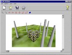
- 3D Visualization
- Multiple Chemicals Run
- Full AERMET Preprocessing
- Full RAMMET Preprocessing
- Extensive Receptor Grids
- Integrated Percentiles and Rolling Averages
- ISC-AERMOD Batcher
- Complete Graphical BPIP for Building Downwash
- isc and AERMAP Terrain Support for DEMs, NTFs, DTMs, CDEDs, GTOPO30 & XYZ
- Import any ISCST3, isc-PRIME or AERMOD Input File
- Professional Report Generation
- Wind Rose Plots and Frequency Analysis
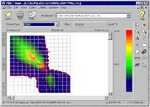
- Integrated Contouring
- Seamless Graphical and/or Text Project Creation
- Support For a Variety of Site Map File Types
- ACE2588 Risk Support
- US EPA-OSW Human Health and Ecological Risk Assessment Support
- Technical Support, Product Upgrades & Free Data
3. Description top
System Requirements
- A IBM or IBM-compatible machine and a Pentium processor or higher
- At least 50 MB of available hard disk space and 32 MB of memory (RAM)
- Windows 95/98/Me or Windows NT/2000
- CD-ROM drive (for installation)
4. Technical summary top
The Industrial Source Complex - Short Term regulatory air dispersion model (ISCST3) is a Gaussian plume model and is widely used to assess pollution concentration and/or deposition flux on receptors, from a wide variety of sources.
AERMOD is the next generation air dispersion model which incorporates planetary boundary layer concepts. Further information about this model can be found by click here.
The Industrial Source Complex - Plume RIse Model Enhancements (isc-PRIME) dispersion model is similar to the ISCST3 model but contains enhanced building downwash analysis.
ISC-AERMOD view interface includes all standard modeling options in addition to the following :
- ISC-AERMOD view has an integrated modeling environment: intuitive data input, model run, and full featured post-processing, with automatic gridding, blanking, contour plotting, and posting of your results.
- Graphical input, where you can use your mouse to graphically define the location of stacks, receptor grids, discrete receptors, and the plant boundary.
- Converts your Cartesian and polar receptor grids into discrete receptors with the option of automatic elimination of receptors within your plant boundary.
- Extracts digital terrain heights for receptor elevations from 1 degree and 7.5 minute USGS Digital Elevation Models (DEMs), UK NTF and DTM, and XYZ formats.
- Automatic creation of your terrain grid file, for dry depletion analysis in elevated or complex terrain, using DEMs.
- isc view User's Guide uses pictures and graphical information to assist you in quickly grasping the manual's contents.
- 3D visualization of your buildings and stacks with true 3D control and the ability to apply any texture to building surfaces.
- The program checks valid ranges for all entry fields which will help save your time by preventing wrong entries.
- You can view all the sources and receptors you have defined for your modeling project graphically in context with one or more site maps (in AutoCAD DXF, USGS DLG, LULC, BMP and Shapfile formats).
- Before running your project, ISC-AERMOD view displays a report of all options selected along with a list of any missing information.
- Powerful post-processor with overlay site-maps in AutoCAD DXF format, USGS DLG and LULC maps, Shapefile and Bitmap images, and automated "no-hassle" shaded contour plots. You can have multiple plots displayed at the same time on the screen. ISC-AERMOD view can also export your modeling results to Surfer.
- Context-sensitive "Help that really helps" which includes status bar tips and full-blown on-line Help. The Help also contains sections of EPA's User's Guide facilitating understanding of the modeling requirements and alternatives.
ISC-AERMOD view comes with a 1 year of free upgrades and 1 year of technical support. You will be able to perform like an expert in no time!
top
Product of Lakes Environmental Software Inc.