The most effective tool to perform realistic 3D air dispersion / pollution modelling
Provides the necessary impact information or air quality assessment to identify environmental strategies and solutions.
1.Introduction top
Since 1996 ATM-PRO searched an effective and realistic Air Modelling software to apply in its consulting activities. It found that (1) the classical Gaussian models, in principles designed for flat terrain or so, are not able to treat complex terrain situations and (2) more sophisticated software are huge consumer of CPU and limited to short term analysis.
Because of this lack in existing commercial tools ATM-PRO develops MAESTRO1 system 1.0 a new 3-D air dispersion model coupling a Lagrangian dispersion model to a meso-meteorological one.
This modelling system allows short term (peaks, ...) and long term (annual mean, ...) integration over complex terrain. Moreover MAESTRO runs on PCs and requires low CPU time.
2. Main Characteristics top
- Realistic impact studies over complex terrain
- Standard meteorological input requirement
- Any source type : punctual, linear, surface or volume
- Comprehensive impact studies : LT & ST analysis
- Cost effective software solution
3. Description top
MAESTRO is a Modelling System for Atmospheric Dispersion of Pollutants dedicated to Environmental impact assessment over Complex Terrain.
Objectives
- Use of adapted numerical model
- Perform realistic impact studies
- Air quality control / regulation compliance
- Environmental strategy development
Theoretical Principles
- 3-D meso-meteorological model (wind field, turb., …)
- Lagrangian type dispersion model
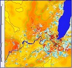
- Topography and land use
- Dry and wet deposition, gravitational settling, plume-rise
Domain
- few kilometres to few tens of kilometres
Validation
- Analytical cases, comparisons to Gaussian model, comparison with field campaign observations, ...
Sources
- Punctual : industrial stacks, ...
- Linear : roads, ...
- Surfaces : heating, ...
- Volumes : pollutant clouds (accidental release, ...)
Inputs
- Topography and land use : site description
- Standard meteorological data (DD, FF, N, RRR, T2, ...)
- Sources description (type, location, emission rates, ...)
Outputs
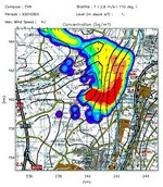
- Classical statistics : annual mean concentration, percentiles, deposits, ...
- Observation series reconstruction over dense networks Detection of critical situations (Meteorological & emissions)
Technique
- PC (> Pentium + 32 Mb RAM)
- Industrial site impact study (~ 2 days CPU)
- Re-usable data base creation (sensitivity tests...)
4. MAESTRO approach top
Implementation for Impact Studies Processing
Inputs
- Site Description
- Meteorological Inputs
- Source Description
- Substances
- Physical Processes
- Output Selection
Process
Output
- Graphical Outputs
- Time Averages
- Percentiles
- Time Series
- Threshold Compliance
- Critical Case Analysis
- Data Base Generation
5. Technical summary top
The MAESTRO model couples an intermediate 3-D meso-meteorological model and a Lagrangian dispersion model.
The meso-meteorological model used is a wind field code based on the formulation of the Navier-Stokes equations. It is run over a region around the site of interest, i.e. a grid of 10 x 10 km or more, depending of the problem. The vertical structure of the atmosphere is computed from similarity theories based on observations. The reduced or simplified formulation enables to get a
stationary solution fitting quite well with the few observations available. This solution can be obtained at reasonable computer cost (CPU) in comparison to Gaussian models or sophisticated 3-D models. It is thus the best compromise between realism and cost. The inputs are classical meteorological data from synoptic weather stations. The main outputs are the realistic wind components and turbulence parameters necessary to compute the dispersion.
The Lagrangian model used in MAESTRO is based on the so-called " kernel " method. This method associates a certain quantity of substance to particles. These are dispersed in the 3-D wind-field produced by the meso-meteorological model which takes into account the terrain
characteristics, i.e. topography and land type roughness. The dispersion model takes into account the dry and wet deposition, the gravitational settling, the plume rise induced for example by the buoyancy of the emitted gases. It can consider various types of sources and substances.
This model runs on PCs Windows at reasonable computer cost.
Product of ATM-PRO sprl.